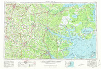
1953 Map of Rocky Mount
USGS Topo · Published 1980About this map
Coastal plains and expansive pocosin wetlands define this mid-century landscape, dominated by the great estuaries of the Albemarle Sound and Pamlico Sound. This region of Eastern North Carolina exhibits a complex interplay between land and water, where the Roanoke River and Tar River navigate toward the coast through dense marshlands like the East Dismal Swamp and Big Pocosin. Interior centers like Goldsboro, Kinston, and Rocky Mount are linked by the Seaboard Coast Line and Norfolk Southern railroads, serving as hubs for the surrounding agricultural and forestry lands such as Hofmann Forest.
Find a feature on this map
345 named features on this map. Tap any name to fly to it.
Don’t see what you’re looking for? This feature index may not catch every label — zoom into the map to look around manually.
Map Details
Editions of this 1953 Rocky Mount Map
4 editions found

Other maps of this area

1901 · New Bern
USGS Topo · 1:62,500

1901 · Parmele
USGS Topo · 1:62,500

1901 · Williamston
USGS Topo · 1:62,500

1902 · Kenly
USGS Topo · 1:62,500

1902 · Williamston
USGS Topo · 1:62,500

1902 · Parmele
USGS Topo · 1:62,500

1902 · Ayden
USGS Topo · 1:62,500

1902 · Rocky Mount
USGS Topo · 1:62,500

1902 · Spring Hope
USGS Topo · 1:62,500

1902 · Vanceboro
USGS Topo · 1:62,500