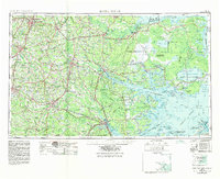
1953 Map of Rocky Mount
USGS Topo · Published 1984About this map
The vast wetlands of eastern North Carolina define this landscape, where the Dismal Swamp and Lake Mattamuskeet dominate the coastal plain. Inland, the map reveals a dense agricultural and transit network centered on regional hubs like Rocky Mount, Greenville, and Goldsboro. This edition highlights the critical role of military installations in the region's mid-century development, specifically Seymour Johnson Air Force Base and Cherry Point Marine Corps Air Station.
Find a feature on this map
241 named features on this map. Tap any name to fly to it.
Don’t see what you’re looking for? This feature index may not catch every label — zoom into the map to look around manually.
Map Details
Editions of this 1953 Rocky Mount Map
4 editions found

Other maps of this area

1901 · New Bern
USGS Topo · 1:62,500

1901 · Parmele
USGS Topo · 1:62,500

1901 · Williamston
USGS Topo · 1:62,500

1902 · Kenly
USGS Topo · 1:62,500

1902 · Williamston
USGS Topo · 1:62,500

1902 · Parmele
USGS Topo · 1:62,500

1902 · Ayden
USGS Topo · 1:62,500

1902 · Rocky Mount
USGS Topo · 1:62,500

1902 · Spring Hope
USGS Topo · 1:62,500

1902 · Vanceboro
USGS Topo · 1:62,500