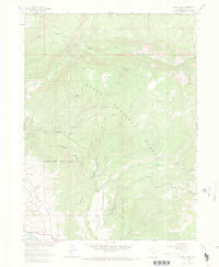
1962 Map of Rocky Peak
USGS Topo · Published 1971About this map
Routt National Forest dominates this mountain landscape, defined by a network of drainage systems feeding into the Yampa River valley. This 1962 field study documents the early infrastructure of the Steamboat Springs area, including the Steamboat Springs Airport and the tracks of the D & R G W railroad near a riverside Gravel Pit. The terrain rises sharply from the river floor toward the heights of Rocky Peak and Copper Ridge, where Jeep Trails and a Lookout Tower provide the only access to the high backcountry.
Find a feature on this map
24 named features on this map. Tap any name to fly to it.
Don’t see what you’re looking for? This feature index may not catch every label — zoom into the map to look around manually.
Map Details
Editions of this 1962 Rocky Peak Map
3 editions found
Other maps of this area

1911 · Hahns Peak
USGS Topo · 1:125,000

1913 · Hahns Peak
USGS Topo · 1:125,000

1954 · Craig
USGS Topo · 1:250,000

1955 · Buffalo Pass
USGS Topo · 1:24,000

1955 · Mount Ethel
USGS Topo · 1:24,000

1955 · Mount Ethel
USGS Topo · 1:62,500

1956 · Storm Mountain
USGS Topo · 1:24,000

1956 · Rabbit Ears Peak
USGS Topo · 1:62,500

1957 · Craig
USGS Topo · 1:250,000

1958 · Craig
USGS Topo · 1:250,000