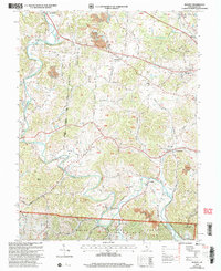
2002 Map of Rodney
USGS Topo · Published 2006About this map
The winding course of Raccoon Creek dictates the geography of this Gallia County landscape, where the Wayne National Forest covers much of the southern terrain. This survey reveals a community defined by its smaller watercourses like Chickamauga Creek and Mud Creek, which cut through the ridges near settlements such as Northup and Adamsville. Evidence of the region’s extractive history is visible in the numerous Strip Mines and Clay Pits scattered across the hillsides, particularly around Rodney.
Find a feature on this map
105 named features on this map. Tap any name to fly to it.
Don’t see what you’re looking for? This feature index may not catch every label — zoom into the map to look around manually.
Map Details
Editions of this 2002 Rodney Map
This is the sole edition of this map. No revisions or reprints were ever made.
Other maps of this area

1906 · Bidwell
USGS Topo · 1:62,500

1906 · Athalia
USGS Topo · 1:62,500

1906 · Glenwood
USGS Topo · 1:62,500

1908 · Bidwell
USGS Topo · 1:62,500

1908 · Athalia
USGS Topo · 1:62,500

1908 · Glenwood
USGS Topo · 1:62,500

1908 · Point Pleasant
USGS Topo · 1:62,500

1926 · Point Pleasant
USGS Topo · 1:62,500

1929 · Point Pleasant
USGS Topo · 1:62,500

1957 · Huntington
USGS Topo · 1:250,000