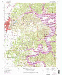
1958 Map of Rogers
USGS Topo · Published 1977About this map
Monte Ne and its surrounding landscape underwent a significant transformation as the waters of Beaver Lake reached into the narrow valleys of the Ozarks. The core of Rogers shows its mid-century footprint, anchored by the St Louis - San Francisco railroad and local institutions like the North Side Sch and South Side Sch. To the east, the rising lake level is meticulously documented, showing the inundation of the White River and the creation of prominent landmarks such as Horseshoe Bend and Monte Ne Shores. Insights into the region's older rural character remain in the numerous family burying grounds, including Mullins Cem and McDaniel Cem, alongside industrial features like the Quarry and the Pumping Station near Lake Atalanta. The map captures a moment when traditional settlements like Frisco were being integrated into a new recreation-focused shoreline economy.
Find a feature on this map
52 named features on this map. Tap any name to fly to it.
Don’t see what you’re looking for? This feature index may not catch every label — zoom into the map to look around manually.
Map Details
Editions of this 1958 Rogers Map
4 editions found

Other maps of this area

1899 · Fayetteville
USGS Topo · 1:125,000

1900 · Eureka Springs
USGS Topo · 1:125,000

1901 · Eureka Springs
USGS Topo · 1:125,000

1901 · Fayetteville
USGS Topo · 1:125,000

1904 · Fayetteville
USGS Topo · 1:125,000

1945 · Harrison
USGS Topo · 1:250,000

1949 · Harrison
USGS Topo · 1:250,000

1954 · Harrison
USGS Topo · 1:250,000

1954 · Tulsa
USGS Topo · 1:250,000

1957 · War Eagle
USGS Topo · 1:24,000