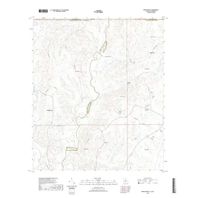
2018 Map of Rogillioville
USGS Topo · Published 2018About this map
Thompson Creek meanders along the boundary of West and East Feliciana Parishes, defining the drainage patterns for this section of the Louisiana-Mississippi borderlands. The landscape is marked by a high density of rural burial grounds, such as Pisgah Cem and McQueen Cem, which serve as vital markers for genealogical research in the vicinity of Rogillioville and Norwood. The terrain is characterized by intricate creek systems, including the West Fork Thompson Creek and Hurricane Cr, which have historically dictated road placement and settlement patterns. Notable landmarks like Sydal Acres Airport and Hickman Bottom reflect the local economy and land use, while named routes such as Trinity Church Ln and Whitstown Rd provide clues to early community hubs. This survey illustrates the persistent rural character of the region, where family names are often preserved in the landscape through features like the Sandel Cem and Singletar Cem.
Find a feature on this map
54 named features on this map. Tap any name to fly to it.
Don’t see what you’re looking for? This feature index may not catch every label — zoom into the map to look around manually.
Map Details
Editions of this 2018 Rogillioville Map
This is the sole edition of this map. No revisions or reprints were ever made.
Other maps of this area

1906 · Bayou Sara
USGS Topo · 1:125,000

1936 · Woodville
USGS Topo · 1:62,500

1939 · St. Francisville
USGS Topo · 1:62,500

1941 · Norwood
USGS Topo · 1:31,680

1941 · Lost Creek
USGS Topo · 1:31,680

1945 · Norwood
USGS Topo · 1:31,680

1945 · Jackson
USGS Topo · 1:31,680

1945 · Lost Creek
USGS Topo · 1:31,680

1946 · Clinton
USGS Topo · 1:31,680

1953 · Natchez
USGS Topo · 1:250,000