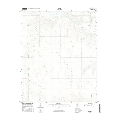
2016 Map of Rolla NE
USGS Topo · Published 2016About this map
The Salt Fork Red River carves a distinctive braided path across the northern reaches of this Texas Panhandle landscape, where the sandy riverbed and intermittent wetlands contrast with the surrounding upland plains. This area of Collingsworth County is defined by a rigorous grid of ranch-to-market roads and county lanes, reflecting the late 20th and early 21st-century agricultural organization of the region. State-maintained routes like FM 1981 and FM 2344 provide the primary infrastructure, while a network of named local roads such as Co Rd 150 and Co Rd M mark out land parcels and access points to the river's drainage basin. Seasonal drainage patterns are further illustrated by Cottonwood Cr, which feeds into the larger river system through the rolling terrain south of the main fork.
Find a feature on this map
18 named features on this map. Tap any name to fly to it.
Don’t see what you’re looking for? This feature index may not catch every label — zoom into the map to look around manually.
Map Details
Editions of this 2016 Rolla NE Map
This is the sole edition of this map. No revisions or reprints were ever made.
Other maps of this area

1954 · Amarillo
USGS Topo · 1:250,000

1954 · Plainview
USGS Topo · 1:250,000

1958 · Amarillo
USGS Topo · 1:250,000

1958 · Plainview
USGS Topo · 1:250,000

1959 · Wellington NW
USGS Topo · 1:24,000

1964 · Rolla SW
USGS Topo · 1:24,000

1964 · Rolla NE
USGS Topo · 1:24,000

1964 · Wellington
USGS Topo · 1:24,000

1964 · Quail
USGS Topo · 1:24,000
1964 · Abra
USGS Topo · 1:24,000