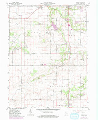
1961 Map of Romney
USGS Topo · Published 1980About this map
Romney and South Raub anchor this corner of Tippecanoe County, where the agricultural landscape is defined by the winding paths of Wea Creek and Little Wea Creek. The Norfolk and Western railroad cuts across the northern terrain, passing through the settlement of Shadeland and near the Shadeland Sch. This 1961 record, with 1980 updates, highlights the established rural infrastructure of Union, Wea, Jackson, and Randolph townships.
Find a feature on this map
34 named features on this map. Tap any name to fly to it.
Don’t see what you’re looking for? This feature index may not catch every label — zoom into the map to look around manually.
Map Details
Editions of this 1961 Romney Map
2 editions found

Other maps of this area

1941 · Lafayette
USGS Topo · 1:24,000

1942 · Otterbein
USGS Topo · 1:24,000

1942 · Lafayette
USGS Topo · 1:24,000

1950 · Lafayette
USGS Topo · 1:24,000

1951 · Otterbein
USGS Topo · 1:24,000

1953 · Danville
USGS Topo · 1:250,000

1955 · Danville
USGS Topo · 1:250,000

1956 · Danville
USGS Topo · 1:250,000

1958 · Linden
USGS Topo · 1:24,000

1958 · Kirkpatrick
USGS Topo · 1:24,000