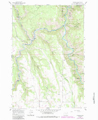
1964 Map of Rondowa
USGS Topo · Published 1984About this map
The Grande Ronde River and Wallowa River converge at the small settlement of Rondowa, where the Union Pacific railroad follows the winding canyon floor. This survey, photogrammetrically mapped in 1959 and photorevised in 1983, captures the rugged boundary between Union Co and Wallowa Co within the Umatilla Nat For and Wallowa-Whitman National Forest. Small communities and outposts like Palmer Junction and Kimmell are linked by a network of trails and unimproved roads, including a noted Pack Trail through the steep terrain. Local history is anchored by landmarks such as Mt Pleasant Cem and Lookingglass Falls, while the landscape is defined by deep drainages like Rysdam Canyon and Duncan Canyon. Numerous Gravel Pits indicate localized extraction activity alongside the primary river arteries that have shaped the region's transport and settlement patterns.
Find a feature on this map
29 named features on this map. Tap any name to fly to it.
Don’t see what you’re looking for? This feature index may not catch every label — zoom into the map to look around manually.
Map Details
Editions of this 1964 Rondowa Map
3 editions found
Other maps of this area

1955 · Grangeville
USGS Topo · 1:250,000

1959 · Grangeville
USGS Topo · 1:250,000

1964 · Partridge Creek
USGS Topo · 1:24,000

1964 · Howard Butte
USGS Topo · 1:24,000

1964 · Cricket Flat
USGS Topo · 1:24,000

1964 · Minam
USGS Topo · 1:24,000

1964 · Elgin
USGS Topo · 1:24,000

1964 · Rondowa
USGS Topo · 1:24,000

1967 · Fry Meadow
USGS Topo · 1:24,000
1967 · Deep Creek
USGS Topo · 1:24,000