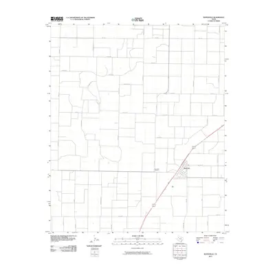
2010 Map of Ropesville
USGS Topo · Published 2010About this map
Ropesville stands as the primary hub of this High Plains landscape, situated at the intersection of several key regional thoroughfares in the early twenty-first century. The town's layout is clearly defined against the surrounding agricultural grid, which is marked by an eclectic naming convention for its rural roads. The area is gridded by routes named for wildlife, such as Oxen Rd, Nightingale Rd, and Hummingbird Rd, reflecting a systematic organization of the Texas panhandle countryside. This map serves as a detailed record of land use and transportation during a period of steady development, anchored by local landmarks like the Ropesville Cemetery west of the main town center. Major transit corridors, including Farm Rd 168, Fm 1585, and Fm 41, provide the structural backbone for the local economy and connectivity between rural homesteads and the township.
Find a feature on this map
33 named features on this map. Tap any name to fly to it.
Don’t see what you’re looking for? This feature index may not catch every label — zoom into the map to look around manually.
Map Details
Editions of this 2010 Ropesville Map
This is the sole edition of this map. No revisions or reprints were ever made.
Other maps of this area

1954 · Brownfield
USGS Topo · 1:250,000

1957 · Meadow
USGS Topo · 1:62,500

1957 · Wolfforth
USGS Topo · 1:62,500

1958 · Brownfield
USGS Topo · 1:250,000

1962 · Brownfield
USGS Topo · 1:250,000

1965 · Levelland East
USGS Topo · 1:24,000

1965 · Lockettville
USGS Topo · 1:24,000

1969 · Sundown SE
USGS Topo · 1:24,000

1976 · Wolfforth SE
USGS Topo · 1:24,000
1976 · Meadow NE
USGS Topo · 1:24,000