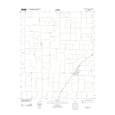
2012 Map of Ropesville
USGS Topo · Published 2012About this map
Ropesville stands as a focal point on this South Plains landscape, where the rectilinear grid of agricultural roads is punctuated by a nomenclature of local fauna. The town's layout is closely tied to the diagonal path of the highway and the intersecting Ranch Road 168, with the Ropesville Cem located just to the west along Old Fm Road 41. This 2012 survey illustrates a highly organized rural geometry, where land divisions are marked by a series of creatively named thoroughfares such as Nightingale Rd, Rattlesnake Rd, and Kingfisher Rd. The map offers a clear view of the settlement's infrastructure, including the neighborhood streets of Arnett St and Timmons St that define the residential core of the community during this era of modern Texas farming.
Find a feature on this map
42 named features on this map. Tap any name to fly to it.
Don’t see what you’re looking for? This feature index may not catch every label — zoom into the map to look around manually.
Map Details
Editions of this 2012 Ropesville Map
This is the sole edition of this map. No revisions or reprints were ever made.
Other maps of this area

1954 · Brownfield
USGS Topo · 1:250,000

1957 · Meadow
USGS Topo · 1:62,500

1957 · Wolfforth
USGS Topo · 1:62,500

1958 · Brownfield
USGS Topo · 1:250,000

1962 · Brownfield
USGS Topo · 1:250,000

1965 · Levelland East
USGS Topo · 1:24,000

1965 · Lockettville
USGS Topo · 1:24,000

1969 · Sundown SE
USGS Topo · 1:24,000

1976 · Wolfforth SE
USGS Topo · 1:24,000
1976 · Meadow NE
USGS Topo · 1:24,000