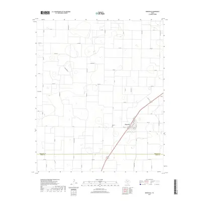
2019 Map of Ropesville
USGS Topo · Published 2019About this map
Ropesville occupies the center of this landscape in the Texas High Plains, where the grid of agricultural roads meets the diagonal path of the main highway. The town's local geography is clearly defined by its residential core, featuring named streets like Arnett Ave and Timmons Ave, and the nearby Ropesville Cem. To the north and west, the terrain is marked by numerous small depressions and playas, a characteristic feature of this region, punctuated by rural markers such as Foster, Rattlesnake, and Tiger. The map captures the boundary line between Hockley Co and Terry Co to the south. An unusual naming convention for rural roads—including Koala Rd, Mongoose Rd, and Roadrunner—adds a distinct character to the surveying of these agricultural blocks, illustrating how modern administrative labeling has overlaid the traditional cotton-farming landscape.
Find a feature on this map
46 named features on this map. Tap any name to fly to it.
Don’t see what you’re looking for? This feature index may not catch every label — zoom into the map to look around manually.
Map Details
Editions of this 2019 Ropesville Map
This is the sole edition of this map. No revisions or reprints were ever made.
Other maps of this area

1954 · Brownfield
USGS Topo · 1:250,000

1957 · Meadow
USGS Topo · 1:62,500

1957 · Wolfforth
USGS Topo · 1:62,500

1958 · Brownfield
USGS Topo · 1:250,000

1962 · Brownfield
USGS Topo · 1:250,000

1965 · Levelland East
USGS Topo · 1:24,000

1965 · Lockettville
USGS Topo · 1:24,000

1969 · Sundown SE
USGS Topo · 1:24,000

1976 · Wolfforth SE
USGS Topo · 1:24,000
1976 · Meadow NE
USGS Topo · 1:24,000