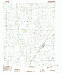
1985 Map of Ropesville
USGS Topo · Published 1985About this map
Ropesville stands as the primary hub of this Llano Estacado landscape in the mid-1980s, positioned along the diagonal route of the Atchison Topeka and Santa Fe RR. The surrounding terrain is defined by a dense network of water resources, with numerous Wells distributed across the plains, indicating the intensive agricultural and industrial demands of the High Plains region. This map provides a detailed view of the infrastructure supporting local life, including the Community Center located northwest of the main town site. Spanning the boundary between Hockley Co and Terry Co, the survey illustrates how regional transport and water management shaped the development of these West Texas communities during this era of rural growth.
Find a feature on this map
5 named features on this map. Tap any name to fly to it.
Don’t see what you’re looking for? This feature index may not catch every label — zoom into the map to look around manually.
Map Details
Editions of this 1985 Ropesville Map
This is the sole edition of this map. No revisions or reprints were ever made.
Other maps of this area

1954 · Brownfield
USGS Topo · 1:250,000

1957 · Meadow
USGS Topo · 1:62,500

1957 · Wolfforth
USGS Topo · 1:62,500

1958 · Brownfield
USGS Topo · 1:250,000

1962 · Brownfield
USGS Topo · 1:250,000

1965 · Levelland East
USGS Topo · 1:24,000

1965 · Lockettville
USGS Topo · 1:24,000

1969 · Sundown SE
USGS Topo · 1:24,000

1976 · Wolfforth SE
USGS Topo · 1:24,000
1976 · Meadow NE
USGS Topo · 1:24,000