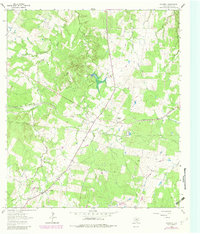
1964 Map of Rosanky
USGS Topo · Published 1982About this map
Missouri Kansas Texas rail lines cut a diagonal path through this corner of Bastrop County, serving the rural community of Rosanky and the nearby settlement of Willman. The landscape is defined by a dense network of watercourses, including Sandy Creek, Piney Creek, and Barton Creek, which drain the varied terrain marked by High Point. This 1964 survey, updated with 1978 photorevisions, captures the transition of the local economy as traditional agriculture and rail transport were augmented by modern infrastructure, such as a prominent Compressor Sta and a network of underground pipelines.
Find a feature on this map
23 named features on this map. Tap any name to fly to it.
Don’t see what you’re looking for? This feature index may not catch every label — zoom into the map to look around manually.
Map Details
Editions of this 1964 Rosanky Map
2 editions found
Other maps of this area

1885 · Bastrop
USGS Topo · 1:125,000

1893 · Bastrop
USGS Topo · 1:125,000

1901 · Flatonia
USGS Topo · 1:125,000

1904 · Bastrop
USGS Topo · 1:125,000

1948 · Smithville
USGS Topo · 1:62,500

1948 · Bastrop
USGS Topo · 1:62,500

1950 · Bastrop
USGS Topo · 1:62,500

1950 · Smithville
USGS Topo · 1:62,500

1953 · Seguin
USGS Topo · 1:250,000

1954 · Austin
USGS Topo · 1:250,000