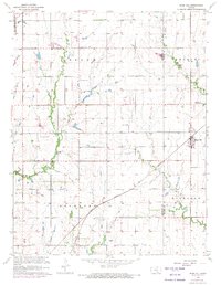
1960 Map of Rose Hill
USGS Topo · Published 1971About this map
Rose Hill serves as the primary hub of this landscape at the intersection of Butler and Sedgwick counties, caught during a period of transition between traditional agriculture and early suburban development. The Atchison Topeka And Santa Fe railroad cuts diagonally across the southern half of the map, marking the historical transit corridor that shaped early Richland and Rockford townships. This 1960 edition, with revisions through 1970, reveals the growing footprint of aviation and leisure near the metropolitan periphery, evidenced by Cook Airfield, Hamilton Airport, and a Country Club. Local genealogy is well-preserved through several established burial grounds, including Branson Cem, Eastridge Cem, and Union Cem. The natural drainage of the prairie is defined by the winding paths of Spring Creek and Eightmile Creek, while the northwestern corner shows the edge of Mc Connell Air Force Base, signaling the increasing importance of military infrastructure to the region's economy.
Find a feature on this map
26 named features on this map. Tap any name to fly to it.
Don’t see what you’re looking for? This feature index may not catch every label — zoom into the map to look around manually.
Map Details
Editions of this 1960 Rose Hill Map
2 editions found
Other maps of this area

1889 · Wichita
USGS Topo · 1:125,000

1890 · Wellington
USGS Topo · 1:125,000

1894 · Wichita
USGS Topo · 1:125,000

1943 · Wichita East
USGS Topo · 1:31,680

1943 · Derby
USGS Topo · 1:31,680

1945 · Andover
USGS Topo · 1:31,680

1955 · Udall
USGS Topo · 1:24,000

1955 · Belle Plaine
USGS Topo · 1:24,000

1955 · Santa Fe Lake
USGS Topo · 1:24,000

1955 · Rose Hill
USGS Topo · 1:24,000