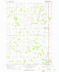
1973 Map of Rosebush
USGS Topo · Published 1976About this map
Rosebush serves as the central hub of this Isabella County landscape, situated along a primary north-south corridor marked by scattered Oil Wells and rural industry. The survey details the intricate Indian Reservation Boundary Road, which bisects the townships of Vernon and Isabella, reflecting the complex historical land divisions of the region. Local life is centered around a network of country churches and community sites, such as St Henrys Ch and its accompanying St Henrys Sch, alongside the Indian Ch located further south.
Find a feature on this map
42 named features on this map. Tap any name to fly to it.
Don’t see what you’re looking for? This feature index may not catch every label — zoom into the map to look around manually.
Map Details
Editions of this 1973 Rosebush Map
This is the sole edition of this map. No revisions or reprints were ever made.
Other maps of this area

1916 · Mount Pleasant
USGS Topo · 1:62,500

1919 · Mount Pleasant
USGS Topo · 1:62,500

1930 · Shepherd
USGS Topo · 1:48,000

1936 · Shepherd
USGS Topo · 1:62,500

1943 · Mount Pleasant
USGS Topo · 1:62,500

1954 · Midland
USGS Topo · 1:250,000

1958 · Midland
USGS Topo · 1:250,000

1959 · Midland
USGS Topo · 1:250,000

1959 · Clare
USGS Topo · 1:62,500

1966 · Midland
USGS Topo · 1:250,000