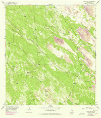
1956 Map of Rosita Lake NE
USGS Topo · Published 1978About this map
Shifting Sand Dunes dominate the landscape of Kenedy County in this mid-century topographic record, reflecting a dynamic environment shaped by wind and sparse water. The area is defined by a network of ranching infrastructure, where water sources are vital to the territory's utility. Family and place-named landmarks like the Huisachito Windmills, Colorado Windmill, and El Burro Windmill are scattered across the terrain, connected by a web of fences and private ranch roads.
Find a feature on this map
29 named features on this map. Tap any name to fly to it.
Don’t see what you’re looking for? This feature index may not catch every label — zoom into the map to look around manually.
Map Details
Editions of this 1956 Rosita Lake NE Map
2 editions found
Other maps of this area

1921 · Tarida Ranch
USGS Topo · 1:62,500

1923 · Lopena Island
USGS Topo · 1:62,500

1923 · Saltillo Ranch
USGS Topo · 1:62,500

1952 · South of Potrero Lopeno NW
USGS Topo · 1:24,000

1952 · Port Mansfield
USGS Topo · 1:24,000

1952 · Potrero Lopeno SW
USGS Topo · 1:24,000

1952 · Potrero Lopeno
USGS Topo · 1:62,500

1952 · South of Potrero Lopeno
USGS Topo · 1:62,500

1953 · Brownsville
USGS Topo · 1:250,000

1956 · Saltillo Well
USGS Topo · 1:24,000