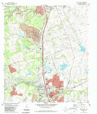
1987 Map of Round Rock
USGS Topo · Published 1987About this map
Inner Space Cavern and the prominent Rabbit Hill anchor the landscape between two growing Texas cities in the late 1980s. The southern portion of the sheet is dominated by the urban expansion of Round Rock, where residential developments are bounded by Brushy Creek and the Missouri Pacific railroad. To the north, the outskirts of Georgetown appear near the South Fork San Gabriel River.
Find a feature on this map
39 named features on this map. Tap any name to fly to it.
Don’t see what you’re looking for? This feature index may not catch every label — zoom into the map to look around manually.
Map Details
Editions of this 1987 Round Rock Map
2 editions found
Other maps of this area

1893 · Georgetown
USGS Topo · 1:125,000

1896 · Austin
USGS Topo · 1:125,000

1897 · Austin
USGS Topo · 1:125,000

1910 · Austin
USGS Topo · 1:125,000

1925 · Georgetown 4-b
USGS Topo · 1:48,000

1925 · Georgetown 4-d
USGS Topo · 1:48,000

1928 · Round Rock
USGS Topo · 1:62,500

1932 · Mt. Bonnell
USGS Topo · 1:62,500

1949 · Round Rock
USGS Topo · 1:62,500

1951 · Round Rock
USGS Topo · 1:62,500