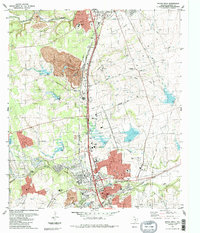
1987 Map of Round Rock
USGS Topo · Published 1987About this map
Inner Space Cavern and the prominent limestone quarry operations define the landscape north of Round Rock in this late 1980s Texas survey. The area exhibits a significant intersection of transport history, where the modern Georgetown Railroad Co and major highways cross the legendary path of the Chisholm Trail. Residential and commercial expansion is evident around the southern edge of Georgetown, while the rural surroundings still preserve small local landmarks like the Old Swedish Cemetery and Genzert Cem. Waterways such as Brushy Creek and Onion Creek meander through the terrain, with more obscure features like the Alligator Hole and Rabbit Hill providing distinctive points of interest for local history researchers and genealogists tracing family names in Williamson County.
Find a feature on this map
35 named features on this map. Tap any name to fly to it.
Don’t see what you’re looking for? This feature index may not catch every label — zoom into the map to look around manually.
Map Details
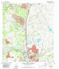
Editions of this 1987 Round Rock Map
2 editions found
Other maps of this area

1893 · Georgetown
USGS Topo · 1:125,000

1896 · Austin
USGS Topo · 1:125,000

1897 · Austin
USGS Topo · 1:125,000

1910 · Austin
USGS Topo · 1:125,000

1925 · Georgetown 4-b
USGS Topo · 1:48,000

1925 · Georgetown 4-d
USGS Topo · 1:48,000

1928 · Round Rock
USGS Topo · 1:62,500

1932 · Mt. Bonnell
USGS Topo · 1:62,500

1949 · Round Rock
USGS Topo · 1:62,500

1951 · Round Rock
USGS Topo · 1:62,500