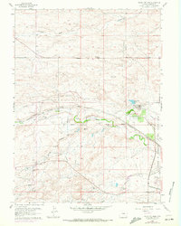
1961 Map of Round Top Lake
USGS Topo · Published 1972About this map
Water management and agricultural research infrastructure dominate this Laramie County landscape, defined by the critical Round Top Pumping Sta and a nearby Filtration Plant. The presence of an extensive aqueduct system and several pipelines underscores the engineering required to support the arid region's growth. At the heart of the sheet, the Department of Agriculture Horticultural Field Station reflects the era's focus on high-plains botany and land use.
Find a feature on this map
24 named features on this map. Tap any name to fly to it.
Don’t see what you’re looking for? This feature index may not catch every label — zoom into the map to look around manually.
Map Details
Editions of this 1961 Round Top Lake Map
4 editions found
Other maps of this area

1905 · Sherman
USGS Topo · 1:125,000

1911 · Cheyenne
USGS Topo · 1:125,000

1914 · Cheyenne
USGS Topo · 1:125,000

1950 · Cheyenne
USGS Topo · 1:62,500

1954 · Cheyenne
USGS Topo · 1:250,000

1958 · Cheyenne
USGS Topo · 1:250,000

1961 · Round Top Lake
USGS Topo · 1:24,000

1961 · Cheyenne South
USGS Topo · 1:24,000
1961 · Borie
USGS Topo · 1:24,000

1961 · Cheyenne
USGS Topo · 1:62,500