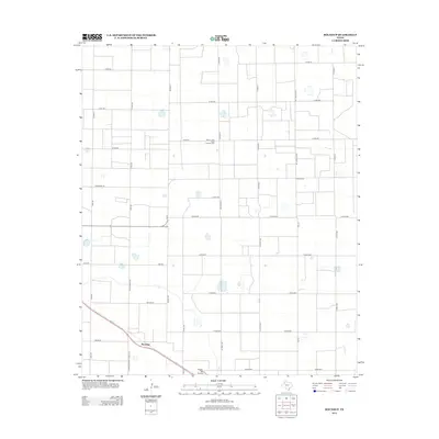
2012 Map of Roundup
USGS Topo · Published 2012About this map
The settlement of Roundup anchors this South Plains landscape at the intersection of several regional transport routes, including State Road 2130 and Maine Rd. This area of the Texas Panhandle is defined by a rigid grid of agricultural roads, such as Co Road A and Co Road B, interspersed with numerous small playa lakes and basins that dot the flat terrain. Industrial activity is concentrated at the Anton - Irish Clear Fork Oil Field, highlighting the region's long-standing connection to petroleum extraction. Further south, Biggin Hill Airport serves as a local aviation landmark near the border with Hockley County. The map also delineates the County Line itself, showing how political boundaries and farm-to-market roads like Fm-179 and Fm-597 shape the movement of people and goods across this productive agricultural and energy-producing territory.
Find a feature on this map
37 named features on this map. Tap any name to fly to it.
Don’t see what you’re looking for? This feature index may not catch every label — zoom into the map to look around manually.
Map Details
Editions of this 2012 Roundup Map
This is the sole edition of this map. No revisions or reprints were ever made.
Other maps of this area

1954 · Lubbock
USGS Topo · 1:250,000

1954 · Brownfield
USGS Topo · 1:250,000

1956 · Shallowater
USGS Topo · 1:24,000

1957 · Lubbock
USGS Topo · 1:62,500

1957 · Anton
USGS Topo · 1:62,500

1957 · Abernathy
USGS Topo · 1:62,500

1957 · Wolfforth
USGS Topo · 1:62,500

1958 · Brownfield
USGS Topo · 1:250,000

1962 · Brownfield
USGS Topo · 1:250,000
1976 · Anton SW
USGS Topo · 1:24,000