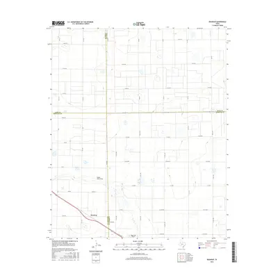
2016 Map of Roundup
USGS Topo · Published 2016About this map
Roundup sits at the intersection of rural South Plains life where the borders of Lubbock, Hockley, Lamb, and Hale counties nearly converge. This West Texas landscape is defined by the ephemeral Yellow House Draw, which winds across a terrain structured by a rigid grid of agricultural roads. The presence of the Biggin Hill Airport south of the main settlement suggests the importance of aerial application and private aviation to the local farming economy. Named roads like Tennessee, King, Leon, and Ohio provide a glimpse into the diverse geographic influences on local naming conventions. The infrastructure here reflects a mid-2010s snapshot of a sparsely populated but highly organized territory dedicated to large-scale agriculture, with the network of County Roads and Farm-to-Market routes like FM 2130 and FM 179 serving as the lifeblood of the region.
Find a feature on this map
41 named features on this map. Tap any name to fly to it.
Don’t see what you’re looking for? This feature index may not catch every label — zoom into the map to look around manually.
Map Details
Editions of this 2016 Roundup Map
This is the sole edition of this map. No revisions or reprints were ever made.
Other maps of this area

1954 · Lubbock
USGS Topo · 1:250,000

1954 · Brownfield
USGS Topo · 1:250,000

1956 · Shallowater
USGS Topo · 1:24,000

1957 · Lubbock
USGS Topo · 1:62,500

1957 · Anton
USGS Topo · 1:62,500

1957 · Abernathy
USGS Topo · 1:62,500

1957 · Wolfforth
USGS Topo · 1:62,500

1958 · Brownfield
USGS Topo · 1:250,000

1962 · Brownfield
USGS Topo · 1:250,000
1976 · Anton SW
USGS Topo · 1:24,000