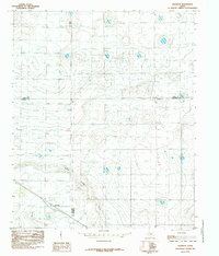
1985 Map of Roundup
USGS Topo · Published 1985About this map
Roundup sits at the intersection of significant agricultural and political boundaries on the Texas High Plains. This 1985 survey captures the landscape during a period of established irrigation and ranching, dominated by the winding path of Yellow House Draw. The map is particularly notable for its depiction of a unique four-county junction, where the borders of Lamb, Hale, Hockley, and Lubbock counties converge. This convergence creates a distinct pattern of property lines and survey blocks that define the region's development. Local researchers can examine the density of wells and the placement of transportation routes that connect this rural hub to the surrounding cattle and cotton country of West Texas.
Find a feature on this map
6 named features on this map. Tap any name to fly to it.
Don’t see what you’re looking for? This feature index may not catch every label — zoom into the map to look around manually.
Map Details
Editions of this 1985 Roundup Map
This is the sole edition of this map. No revisions or reprints were ever made.
Other maps of this area

1954 · Lubbock
USGS Topo · 1:250,000

1954 · Brownfield
USGS Topo · 1:250,000

1956 · Shallowater
USGS Topo · 1:24,000

1957 · Lubbock
USGS Topo · 1:62,500

1957 · Anton
USGS Topo · 1:62,500

1957 · Abernathy
USGS Topo · 1:62,500

1957 · Wolfforth
USGS Topo · 1:62,500

1958 · Brownfield
USGS Topo · 1:250,000

1962 · Brownfield
USGS Topo · 1:250,000
1976 · Anton SW
USGS Topo · 1:24,000