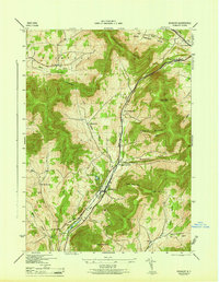
1946 Map of Roxbury
USGS Topo · Published 1946About this map
Roxbury and the high peaks of the Moresville Range anchor this 1945 survey of the Catskill Mountains. The landscape is defined by the New York Central railroad corridor, which follows the winding path of the East Branch Delaware River through narrow valleys. This mountain terrain is characterized by numerous family-named hollows and settlements, including the Moffit Settlement and West Settlement, illustrating the scattered agricultural and residential patterns of the mid-20th century. High elevations like Irish Mtn and Schultice Mountain hem in the developed corridors, where local landmarks such as the Township Ch and Tyler Cem provide critical reference points for genealogical research. The map also captures infrastructure such as the Grand Gorge Sta, showing how rail transport linked these remote Delaware County communities to the wider region.
Find a feature on this map
38 named features on this map. Tap any name to fly to it.
Don’t see what you’re looking for? This feature index may not catch every label — zoom into the map to look around manually.
Map Details
Editions of this 1946 Roxbury Map
This is the sole edition of this map. No revisions or reprints were ever made.
Other maps of this area

1900 · Phoenicia
USGS Topo · 1:62,500

1901 · Margaretville
USGS Topo · 1:62,500

1901 · Gilboa
USGS Topo · 1:62,500

1903 · Gilboa
USGS Topo · 1:62,500

1903 · Phoenicia
USGS Topo · 1:62,500

1904 · Hobart
USGS Topo · 1:62,500

1904 · Margaretville
USGS Topo · 1:62,500

1945 · West Kill
USGS Topo · 1:24,000

1945 · Gilboa
USGS Topo · 1:24,000

1945 · Fleischmanns
USGS Topo · 1:24,000