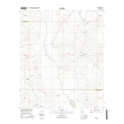
2015 Map of Roy
USGS Topo · Published 2015About this map
Black Lake Bayou winds through this North Louisiana landscape, marking a prominent natural boundary in a region defined by its rural settlements and parish lines. In the southern portion of the sheet, the community of Martin is surrounded by a network of local roads including Minden Rd and Britnell Rd, while the settlement of Ashland sits further east near Oil Field Rd. The map illustrates a high density of historical landmarks for genealogists, featuring numerous burial sites such as Luke Cem, Bethel Cem, and Newman Cem. Small clusters of homes and family-named roads like Samuel Rd and Myers Rd are scattered among the tributaries of Castor Cr and Nelson Cr, providing a detailed look at the parish crossroads of Alberta, Roy, and Ebenezer during the mid-2010s.
Find a feature on this map
95 named features on this map. Tap any name to fly to it.
Don’t see what you’re looking for? This feature index may not catch every label — zoom into the map to look around manually.
Map Details
Editions of this 2015 Roy Map
This is the sole edition of this map. No revisions or reprints were ever made.
Other maps of this area

1947 · Ringgold
USGS Topo · 1:62,500

1947 · Ashland
USGS Topo · 1:62,500

1948 · Coushatta
USGS Topo · 1:62,500

1948 · Jamestown
USGS Topo · 1:62,500

1949 · Jamestown
USGS Topo · 1:62,500

1955 · Shreveport
USGS Topo · 1:250,000

1956 · Shreveport
USGS Topo · 1:250,000

1956 · Ringgold
USGS Topo · 1:62,500
1957 · Coushatta
USGS Topo · 1:62,500

1957 · Ashland
USGS Topo · 1:62,500