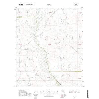
2018 Map of Roy
USGS Topo · Published 2018About this map
Black Lake Bayou dominates the central landscape of this 2018 survey, its expansive wetlands and winding course creating a natural boundary between Red River, Bienville, and Natchitoches Parishes. The region is characterized by small, dispersed rural settlements and several historical focal points for local genealogy. In the south, the village of Martin is surrounded by family-named landmarks like Holly Springs Cem and Newman Cem. To the north, the community of Alberta and the namesake Roy sit along a network of secondary roads such as Myers Rd and Punkin Center Rd.
Find a feature on this map
84 named features on this map. Tap any name to fly to it.
Don’t see what you’re looking for? This feature index may not catch every label — zoom into the map to look around manually.
Map Details
Editions of this 2018 Roy Map
This is the sole edition of this map. No revisions or reprints were ever made.
Other maps of this area

1947 · Ringgold
USGS Topo · 1:62,500

1947 · Ashland
USGS Topo · 1:62,500

1948 · Coushatta
USGS Topo · 1:62,500

1948 · Jamestown
USGS Topo · 1:62,500

1949 · Jamestown
USGS Topo · 1:62,500

1955 · Shreveport
USGS Topo · 1:250,000

1956 · Shreveport
USGS Topo · 1:250,000

1956 · Ringgold
USGS Topo · 1:62,500
1957 · Coushatta
USGS Topo · 1:62,500

1957 · Ashland
USGS Topo · 1:62,500