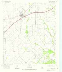
1963 Map of Royse City
USGS Topo · Published 1976About this map
Royse City serves as the primary hub of this north Texas landscape in the early 1960s, situated where the Missouri Kansas - Texas railroad intersects with major regional thoroughfares. The map detail highlights the town's mid-century infrastructure, from the Filtration Plant and Landing Strip to the local Athletic Field. Beyond the city limits, the terrain is defined by the headwaters and branches of the South Fork Sabine River, including Bois d'Arc Creek and Sabine Creek. These waterways dictate the placement of small rural communities like Blackland, while the Blackland Cem and family-named sites such as Zollner Ranch provide essential data points for genealogical research. The presence of Storage Bins and a Gaging Sta 478 further illustrates the agricultural and hydrological management of the Rockwall and Hunt County borderlands.
Find a feature on this map
28 named features on this map. Tap any name to fly to it.
Don’t see what you’re looking for? This feature index may not catch every label — zoom into the map to look around manually.
Map Details
Editions of this 1963 Royse City Map
2 editions found
Other maps of this area

1912 · Rockwall
USGS Topo · 1:31,680

1919 · Royse City
USGS Topo · 1:62,500

1924 · Farmersville 3-c
USGS Topo · 1:48,000

1930 · Farmersville
USGS Topo · 1:62,500

1954 · Dallas
USGS Topo · 1:250,000

1954 · Sherman
USGS Topo · 1:250,000

1956 · Quinlan
USGS Topo · 1:62,500

1958 · Dallas
USGS Topo · 1:250,000

1958 · Sherman
USGS Topo · 1:250,000

1962 · Greenville SW
USGS Topo · 1:24,000