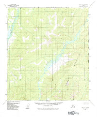
1952 Map of Ruby A-1
USGS Topo · Published 1984About this map
The Sischu Mountains dominate this interior Alaskan landscape, providing a high-relief backdrop to a complex network of waterways. The Sethkokna River meanders across the central valley, its serpentine course indicating a low-gradient drainage system typical of the region's wilderness corridors. To the west, the Telsitna River carves through the terrain, while the Kateel River Meridian serves as the primary longitudinal reference for this unsurveyed territory. Significant elevation points like VABM 2818 Baker anchor the topography, overlooking the headwaters of Baker Creek and Sischu Creek. This map illustrates a pristine environment before significant infrastructure development, where the land is defined solely by its natural drainage patterns and the prominent ridges of the Sischu range.
Find a feature on this map
8 named features on this map. Tap any name to fly to it.
Don’t see what you’re looking for? This feature index may not catch every label — zoom into the map to look around manually.
Map Details
Editions of this 1952 Ruby A-1 Map
2 editions found
Other maps of this area

1948 · Kantishna River
USGS Topo · 1:250,000

1950 · Medfra
USGS Topo · 1:250,000

1951 · Kantishna River
USGS Topo · 1:250,000

1951 · Ruby
USGS Topo · 1:250,000

1952 · Mount McKinley
USGS Topo · 1:250,000

1952 · Ruby A-2
USGS Topo · 1:63,360

1952 · Ruby B-1
USGS Topo · 1:63,360

1952 · Ruby B-2
USGS Topo · 1:63,360

1952 · Ruby A-1
USGS Topo · 1:63,360

1952 · Kantishna River
USGS Topo · 1:250,000