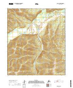
2019 Map of Ruby B-2 NE
USGS Topo · Published 2019About this map
The Nowitna River snakes through this Interior Alaska landscape, defining a complex system of oxbows and ancient meanders within the t12s r26e and t12s r27e township boundaries. The river's broad floodplain contrasts sharply with the rising elevation of the surrounding uplands, which climb toward distinct ridges in the southern portion of the quadrangle. In the northern reaches, the confluence of the Big Mud River and Grand Cr creates a network of wetlands and shifting channels. This terrain represents a preserved wilderness environment where the natural movement of the waterways remains the primary architect of the land, untouched by road development or permanent settlements at the time of this 2019 survey.
Find a feature on this map
9 named features on this map. Tap any name to fly to it.
Don’t see what you’re looking for? This feature index may not catch every label — zoom into the map to look around manually.
Map Details
Editions of this 2019 Ruby B-2 NE Map
This is the sole edition of this map. No revisions or reprints were ever made.
Other maps of this area

1951 · Ruby
USGS Topo · 1:250,000

1952 · Ruby B-1
USGS Topo · 1:63,360

1952 · Ruby B-2
USGS Topo · 1:63,360

1952 · Ruby C-1
USGS Topo · 1:63,360

1952 · Ruby C-2
USGS Topo · 1:63,360

1952 · Ruby
USGS Topo · 1:250,000

1964 · Ruby
USGS Topo · 1:250,000
2019 · Ruby B-1 SW
USGS Topo · 1:25,000
2019 · Ruby B-2 NW
USGS Topo · 1:25,000
2019 · Ruby C-2 SE
USGS Topo · 1:25,000