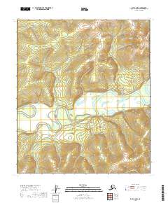
2019 Map of Ruby B-2 NW
USGS Topo · Published 2019About this map
Nowitna River winds through the heart of this landscape, its expansive meanders and oxbows defining the topography within the Yukon-Koyukuk Census Area. The river's broad floodplains are a stark contrast to the surrounding high ground, which rises into prominent ridges and valleys to the north and south. This terrain is meticulously organized by the Public Land Survey System, with township and range lines like t12s r25e and t13s r25e providing the primary navigational grid across the interior. The lack of named roads or permanent settlements in this specific quadrant highlights the wilderness character of the region, where the river serves as the primary corridor for movement through the interior of Alaska.
Find a feature on this map
9 named features on this map. Tap any name to fly to it.
Don’t see what you’re looking for? This feature index may not catch every label — zoom into the map to look around manually.
Map Details
Editions of this 2019 Ruby B-2 NW Map
This is the sole edition of this map. No revisions or reprints were ever made.
Other maps of this area

1951 · Ruby
USGS Topo · 1:250,000

1952 · Ruby B-2
USGS Topo · 1:63,360

1952 · Ruby C-3
USGS Topo · 1:63,360

1952 · Ruby C-2
USGS Topo · 1:63,360

1952 · Ruby B-3
USGS Topo · 1:63,360

1952 · Ruby
USGS Topo · 1:250,000
1953 · Ruby B-3
USGS Topo · 1:63,360

1964 · Ruby
USGS Topo · 1:250,000
2019 · Ruby C-2 SE
USGS Topo · 1:25,000
2019 · Ruby B-2 NE
USGS Topo · 1:25,000