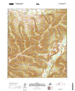
2019 Map of Ruby C-2 SE
USGS Topo · Published 2019About this map
Grand Cr meanders through this interior Alaska landscape, providing the primary drainage for the surrounding uplands within the Ruby C-2 SE quadrangle. The terrain is defined by a dense network of ridges and drainages, mapped with 20-foot contour intervals that reveal the complex topography of the Yukon-Koyukuk region. This 2019 survey reflects the modern digital mapping era, utilizing imagery from 2008 and elevation data from 2018 to delineate the land. The map is heavily structured by the Public Land Survey System, showing the transition between t10s r26e, t10s r27e, t11s r26e, and t11s r27e. This specific section of the Alaskan wilderness remains largely devoid of named human infrastructure, emphasizing the natural water systems like Grand Cr as the primary landmarks for navigation and local geography.
Find a feature on this map
5 named features on this map. Tap any name to fly to it.
Don’t see what you’re looking for? This feature index may not catch every label — zoom into the map to look around manually.
Map Details
Editions of this 2019 Ruby C-2 SE Map
This is the sole edition of this map. No revisions or reprints were ever made.
Other maps of this area

1951 · Ruby
USGS Topo · 1:250,000

1952 · Ruby B-1
USGS Topo · 1:63,360

1952 · Ruby B-2
USGS Topo · 1:63,360

1952 · Ruby C-1
USGS Topo · 1:63,360

1952 · Ruby C-2
USGS Topo · 1:63,360

1952 · Ruby
USGS Topo · 1:250,000

1964 · Ruby
USGS Topo · 1:250,000
2019 · Ruby B-2 NW
USGS Topo · 1:25,000
2019 · Ruby B-2 NE
USGS Topo · 1:25,000
2019 · Ruby B-1 NW
USGS Topo · 1:25,000