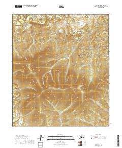
2019 Map of Ruby B-4 NE
USGS Topo · Published 2019About this map
The Monzonite Hills dominate the central terrain of this quadrangle in the Yukon-Koyukuk Census Area, rising as a prominent upland between several drainage systems. The Sulatna River winds through the northwestern corner of the sheet, while Monzonite Cr and Valley Cr define the lower elevations to the south and east. This landscape remains largely undeveloped, showcasing the intricate topographic contours of interior Alaska and the natural hydrography that dictates the flow of water away from the high points of the hills. The map provides a detailed record of the relief and waterway patterns, which are essential for understanding the remote geography and seasonal environmental changes in this subarctic region.
Find a feature on this map
10 named features on this map. Tap any name to fly to it.
Don’t see what you’re looking for? This feature index may not catch every label — zoom into the map to look around manually.
Map Details
Editions of this 2019 Ruby B-4 NE Map
This is the sole edition of this map. No revisions or reprints were ever made.
Other maps of this area

1951 · Ruby
USGS Topo · 1:250,000

1952 · Ruby C-3
USGS Topo · 1:63,360

1952 · Ruby B-4
USGS Topo · 1:63,360

1952 · Ruby B-3
USGS Topo · 1:63,360

1952 · Ruby C-4
USGS Topo · 1:63,360

1952 · Ruby
USGS Topo · 1:250,000
1953 · Ruby B-3
USGS Topo · 1:63,360

1964 · Ruby
USGS Topo · 1:250,000
2019 · Ruby B-3 NW
USGS Topo · 1:25,000
2019 · Ruby C-3 SW
USGS Topo · 1:25,000