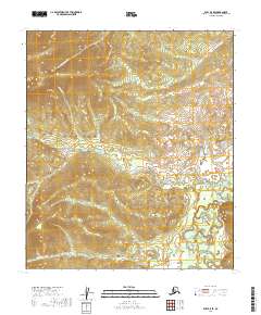
2019 Map of Ruby B-5 SE
USGS Topo · Published 2019About this map
The Sulatna River winds through this interior landscape, defining a complex drainage system within the Yukon-Koyukuk region. This 2019 survey documents a network of gold-bearing watercourses, including Quartz Cr and Gold Cr, which converge from the surrounding hills. These waterways carry names common to early 20th-century prospecting, suggesting a landscape shaped by historical mining interest. The terrain is characterized by prominent landforms such as Lucky Gulch and Little Dome Cr, marking the rugged topography north of the river. Other tributaries like White Channel Cr, Diamond Cr, and Antelope Cr further delineate the local watershed, providing a detailed record of the physical geography and established nomenclature of this remote Alaska quadrangle.
Find a feature on this map
15 named features on this map. Tap any name to fly to it.
Don’t see what you’re looking for? This feature index may not catch every label — zoom into the map to look around manually.
Map Details
Editions of this 2019 Ruby B-5 SE Map
This is the sole edition of this map. No revisions or reprints were ever made.
Other maps of this area

1951 · Ruby
USGS Topo · 1:250,000

1952 · Ruby A-4
USGS Topo · 1:63,360

1952 · Ruby B-4
USGS Topo · 1:63,360

1952 · Ruby B-5
USGS Topo · 1:63,360

1952 · Ruby A-5
USGS Topo · 1:63,360

1952 · Ruby
USGS Topo · 1:250,000

1964 · Ruby
USGS Topo · 1:250,000
2019 · Ruby A-4 NW
USGS Topo · 1:25,000
2019 · Ruby B-5 NE
USGS Topo · 1:25,000
2019 · Ruby A-5 NW
USGS Topo · 1:25,000