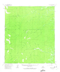
1952 Map of Ruby B-5
USGS Topo · Published 1975About this map
The Sulatna River watershed dominates this interior Alaskan landscape, which was characterized by active gold mining operations during the early 1950s. The settlement of Long serves as a focal point near Bear Gulch, where a Placer Mine and several cabins suggest a localized extractive economy. To the north along Birch Creek, a Strip Mine further illustrates the industrial footprint in the territory during this era.
Find a feature on this map
43 named features on this map. Tap any name to fly to it.
Don’t see what you’re looking for? This feature index may not catch every label — zoom into the map to look around manually.
Map Details
Editions of this 1952 Ruby B-5 Map
2 editions found
Other maps of this area

1951 · Ruby
USGS Topo · 1:250,000

1952 · Ruby A-4
USGS Topo · 1:63,360

1952 · Ruby B-6
USGS Topo · 1:63,360

1952 · Ruby B-4
USGS Topo · 1:63,360

1952 · Ruby C-5
USGS Topo · 1:63,360

1952 · Ruby B-5
USGS Topo · 1:63,360

1952 · Ruby A-5
USGS Topo · 1:63,360

1952 · Ruby C-4
USGS Topo · 1:63,360

1952 · Ruby A-6
USGS Topo · 1:63,360

1952 · Ruby C-6
USGS Topo · 1:63,360