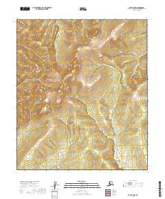
2019 Map of Ruby B-6 NW
USGS Topo · Published 2019About this map
Yuki Mtn dominates the high ground of this interior Alaskan landscape, serving as a primary topographical landmark in the Yukon-Koyukuk region. The drainage patterns on this 2019 survey are clearly defined by the N Fork Sulatna River, which winds through the southern and eastern portions of the quadrangle. In the northeast corner, Main Cr carves a narrow valley, illustrating the headwater systems typical of this part of the subarctic wilderness. The map is primarily characterized by its remote elevation contours and the absence of established road infrastructure or settlements, reflecting a territory defined almost entirely by its natural hydrology and high-altitude terrain.
Find a feature on this map
11 named features on this map. Tap any name to fly to it.
Don’t see what you’re looking for? This feature index may not catch every label — zoom into the map to look around manually.
Map Details
Editions of this 2019 Ruby B-6 NW Map
This is the sole edition of this map. No revisions or reprints were ever made.
Other maps of this area

1945 · Nulato
USGS Topo · 1:250,000

1951 · Nulato
USGS Topo · 1:250,000

1951 · Ruby
USGS Topo · 1:250,000

1952 · Nulato C-1
USGS Topo · 1:63,360

1952 · Nulato B-1
USGS Topo · 1:63,360

1952 · Ruby B-6
USGS Topo · 1:63,360

1952 · Ruby C-6
USGS Topo · 1:63,360

1952 · Nulato
USGS Topo · 1:250,000

1952 · Ruby
USGS Topo · 1:250,000
1953 · Nulato B-1
USGS Topo · 1:63,360