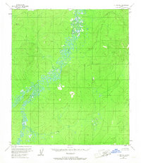
1953 Map of Nulato B-1
USGS Topo · Published 1967About this map
The Yuki River meanders through this interior Alaska landscape, joined by its East Fork in a region defined by complex river hydraulics and expansive wetlands. Mapped primarily through photogrammetric methods from 1952 aerial photography, the terrain is characterized by intricate oxbow lakes and shifting gravel bars along the river corridors. The absence of established roads or permanent settlements in this mid-century survey reflects the wilderness character of the area near the Kateel River Meridian. The topography consists of low-lying swampy basins interspersed with rising elevations, providing a clear record of the natural drainage patterns of the Yuki River basin before later development or environmental shifts altered these remote waterways.
Find a feature on this map
2 named features on this map. Tap any name to fly to it.
Don’t see what you’re looking for? This feature index may not catch every label — zoom into the map to look around manually.
Map Details
Editions of this 1953 Nulato B-1 Map
This is the sole edition of this map. No revisions or reprints were ever made.
Other maps of this area

1945 · Nulato
USGS Topo · 1:250,000

1951 · Nulato
USGS Topo · 1:250,000

1951 · Ruby
USGS Topo · 1:250,000

1952 · Nulato C-1
USGS Topo · 1:63,360

1952 · Nulato B-2
USGS Topo · 1:63,360

1952 · Nulato B-1
USGS Topo · 1:63,360

1952 · Nulato C-2
USGS Topo · 1:63,360

1952 · Ruby B-6
USGS Topo · 1:63,360

1952 · Nulato A-2
USGS Topo · 1:63,360

1952 · Ruby A-6
USGS Topo · 1:63,360