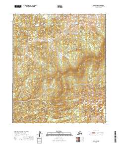
2019 Map of Ruby D-2 SW
USGS Topo · Published 2019About this map
Unsurveyed wilderness dominates this 2019 study of the Yukon-Koyukuk region, where the landscape is defined by its topographic relief rather than human settlement. The territory is organized under the Public Land Survey System within T7s R24e, T7s R25e, T8s R24e, and T8s R25e. Unlike maps of developed regions, this sheet contains no named roads, settlements, or structures, offering a specialized look at the drainage patterns and elevation profiles of the Alaska interior. The absence of geographic names beyond these township and range markers emphasizes the remote character of this terrain as it stood in the early twenty-first century, serving primarily as a baseline for environmental and topographic study in one of the state's most sparsely populated census areas.
Find a feature on this map
4 named features on this map. Tap any name to fly to it.
Don’t see what you’re looking for? This feature index may not catch every label — zoom into the map to look around manually.
Map Details
Editions of this 2019 Ruby D-2 SW Map
This is the sole edition of this map. No revisions or reprints were ever made.
Other maps of this area

1951 · Ruby
USGS Topo · 1:250,000

1952 · Ruby C-3
USGS Topo · 1:63,360

1952 · Ruby C-2
USGS Topo · 1:63,360

1952 · Ruby D-3
USGS Topo · 1:63,360

1952 · Ruby D-2
USGS Topo · 1:63,360

1952 · Ruby
USGS Topo · 1:250,000

1964 · Ruby
USGS Topo · 1:250,000
2019 · Ruby D-2 NE
USGS Topo · 1:25,000
2019 · Ruby D-2 SE
USGS Topo · 1:25,000
2019 · Ruby D-2 NW
USGS Topo · 1:25,000