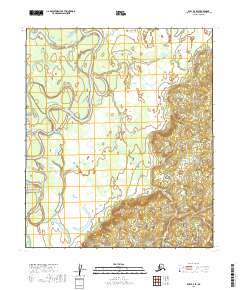
2019 Map of Ruby D-3 SE
USGS Topo · Published 2019About this map
Nowitna River meanders across this northern interior landscape, carving a complex series of oxbows and abandoned channels through the lowlands. The river is the defining physical feature of this 2019 survey, illustrating the dynamic hydrology of the Yukon-Koyukuk region. A distinctive geographic formation known as The Loop highlights the extreme winding nature of the waterway as it flows through these subarctic wetlands. The map provides a detailed view of the Public Land Survey System divisions, including t7s r23e and t8s r24e, which help orient researchers to specific parcels within this roadless terrain. This area remains primarily defined by its natural watercourses and the lack of permanent human structures, reflecting the characteristic wilderness of central Alaska.
Find a feature on this map
6 named features on this map. Tap any name to fly to it.
Don’t see what you’re looking for? This feature index may not catch every label — zoom into the map to look around manually.
Map Details
Editions of this 2019 Ruby D-3 SE Map
This is the sole edition of this map. No revisions or reprints were ever made.
Other maps of this area

1951 · Ruby
USGS Topo · 1:250,000

1952 · Ruby C-3
USGS Topo · 1:63,360

1952 · Ruby C-2
USGS Topo · 1:63,360

1952 · Ruby D-3
USGS Topo · 1:63,360

1952 · Ruby D-2
USGS Topo · 1:63,360

1952 · Ruby
USGS Topo · 1:250,000

1964 · Ruby
USGS Topo · 1:250,000
2019 · Ruby D-2 NW
USGS Topo · 1:25,000
2019 · Ruby C-2 NW
USGS Topo · 1:25,000
2019 · Ruby D-2 SW
USGS Topo · 1:25,000