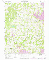
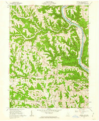
1961 Map of Ruraldale
USGS Topo · Published 1977About this map
The hills of Muskingum County are deeply carved by Salt Creek and its many tributaries, defining a landscape of narrow ridges and hollows such as Harmony Hollow and Coal Hollow. This survey captures the rural character of southeastern Ohio before significant modern redevelopment, highlighting the importance of small upland communities like Ruraldale and Museville. The land use is a mix of conservation and extraction, with the Blue Rock State Forest and Blue Rock State Reserve bordering active Strip Mines and several oil wells.
Find a feature on this map
39 named features on this map. Tap any name to fly to it.
Don’t see what you’re looking for? This feature index may not catch every label — zoom into the map to look around manually.
Map Details
Editions of this 1961 Ruraldale Map
4 editions found
Other maps of this area

1909 · Caldwell
USGS Topo · 1:62,500

1910 · Philo
USGS Topo · 1:62,500

1910 · Mc Connelsville
USGS Topo · 1:62,500

1911 · Cumberland
USGS Topo · 1:62,500

1912 · Caldwell
USGS Topo · 1:62,500

1949 · Clarksburg
USGS Topo · 1:250,000

1956 · Clarksburg
USGS Topo · 1:250,000

1961 · Clarksburg
USGS Topo · 1:250,000

1961 · Mc Connelsville
USGS Topo · 1:24,000
1961 · Rokeby Lock
USGS Topo · 1:24,000