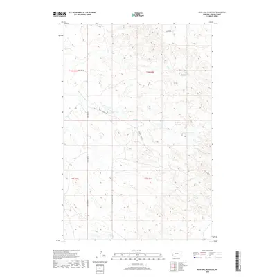
2020 Map of Rush Hall Reservoir
USGS Topo · Published 2020About this map
Rush Hall Reservoir serves as a focal point in this high-plains landscape of eastern Montana, where the drainage networks of Middle Fork Cabin Cr and Cabin Cr carve intricate patterns through the terrain. The map documents a sparsely populated ranching and rangeland environment, defined by its system of dirt tracks and trails. To the north, the waters of Wills Cr flow through the breaks, while transportation is limited to established routes such as Cap Rock Rd and Cabin Creek Rd. Of particular interest to those studying the geography of the area is the Battleship Butte Trl, which suggests the presence of distinctive local landforms used for navigation and recreation in this corner of Fallon County.
Find a feature on this map
11 named features on this map. Tap any name to fly to it.
Don’t see what you’re looking for? This feature index may not catch every label — zoom into the map to look around manually.
Map Details
Editions of this 2020 Rush Hall Reservoir Map
This is the sole edition of this map. No revisions or reprints were ever made.
Other maps of this area

1953 · Miles City
USGS Topo · 1:250,000

1957 · Miles City
USGS Topo · 1:250,000

1958 · Miles City
USGS Topo · 1:250,000
1981 · Baker
USGS Topo · 1:100,000
1981 · Baker NE
USGS Topo · 1:24,000
1981 · Lawrence Creek East
USGS Topo · 1:24,000
1981 · Baker NW
USGS Topo · 1:24,000
1981 · Morris Butte
USGS Topo · 1:24,000
1981 · Cap Rock
USGS Topo · 1:24,000
1981 · Rocking Chair Butte
USGS Topo · 1:24,000