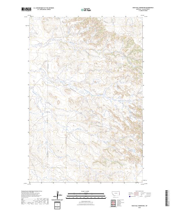
2024 Map of Rush Hall Reservoir
USGS Topo · Published 2024About this map
Rush Hall Reservoir sits as a primary water source in this corner of the eastern Montana high plains, surrounded by the drainage networks of Wills Creek and the Middle Fork Cabin Creek. This 2024 survey of the Fallon County landscape reveals a region defined by its hydrology and the sparse trail systems that navigate the breaks. The prominent Battleship Butte Trl cuts across the central terrain, providing access through the varied elevations that characterize this part of the state. Managed primarily through rural road networks like Cabin Creek Rd and Cap Rock Rd, the area maintains a distinctively open character, where the interplay of seasonal waterways like Cabin Creek and the man-made reservoir dictates the land's utility and the reach of local ranching operations.
Find a feature on this map
11 named features on this map. Tap any name to fly to it.
Don’t see what you’re looking for? This feature index may not catch every label — zoom into the map to look around manually.
Map Details
Editions of this 2024 Rush Hall Reservoir Map
This is the sole edition of this map. No revisions or reprints were ever made.
Other maps of this area

1953 · Miles City
USGS Topo · 1:250,000

1957 · Miles City
USGS Topo · 1:250,000

1958 · Miles City
USGS Topo · 1:250,000

1981 · Baker
USGS Topo · 1:100,000

1981 · Baker NE
USGS Topo · 1:24,000

1981 · Lawrence Creek East
USGS Topo · 1:24,000

1981 · Baker NW
USGS Topo · 1:24,000
1981 · Morris Butte
USGS Topo · 1:24,000

1981 · Cap Rock
USGS Topo · 1:24,000

1981 · Rocking Chair Butte
USGS Topo · 1:24,000