
1952 Map of Russian Mission C-1
USGS Topo · Published 1960About this map
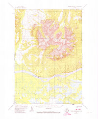
The Russian Mission settlement occupies a strategic position along the north bank of the Kuskokwim River, serving as a focal point for navigation and transport in this interior Alaskan landscape. To the north, the massive Russian Mountains dominate the terrain, their high peaks including Vabm Sharp and several unnamed summits reaching over 3,000 feet. The drainage system is clearly defined by several significant water bodies, such as the Owhat River and Mission Creek, which carve through the foothills to reach the main river valley.
Find a feature on this map
13 named features on this map. Tap any name to fly to it.
Don’t see what you’re looking for? This feature index may not catch every label — zoom into the map to look around manually.
Map Details
Editions of this 1952 Russian Mission C-1 Map
2 editions found
Other maps of this area

1947 · Russian Mission
USGS Topo · 1:250,000

1950 · Russian Mission
USGS Topo · 1:250,000

1950 · Sleetmute
USGS Topo · 1:250,000

1952 · Russian Mission D-2
USGS Topo · 1:63,360

1952 · Russian Mission D-1
USGS Topo · 1:63,360

1952 · Russian Mission C-2
USGS Topo · 1:63,360

1952 · Russian Mission B-2
USGS Topo · 1:63,360
1952 · Russian Mission B-1
USGS Topo · 1:63,360
1954 · Sleetmute C-8
USGS Topo · 1:63,360
1954 · Sleetmute D-8
USGS Topo · 1:63,360