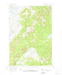
1952 Map of Russian Mission D-1
USGS Topo · Published 1973About this map
Molybdenum Mountain stands as a prominent landmark in this interior Alaskan landscape, which was photogrammetrically mapped in the early 1950s. The terrain is defined by the winding course of the Owhat River and its various tributaries, including the aptly named Cobalt Creek. This survey captures a region of significant elevation changes and drainage patterns before modern development altered the remote wilderness. The presence of a dedicated Winter Trail cutting through the eastern portion of the sheet highlights the importance of seasonal travel routes in an era when permanent road infrastructure was largely nonexistent. These trails served as critical corridors for local movement across the varied topography of the Russian Mission quadrangle, connecting isolated points through the river valleys and high ridges.
Find a feature on this map
4 named features on this map. Tap any name to fly to it.
Don’t see what you’re looking for? This feature index may not catch every label — zoom into the map to look around manually.
Map Details
Editions of this 1952 Russian Mission D-1 Map
3 editions found
Other maps of this area

1947 · Russian Mission
USGS Topo · 1:250,000

1950 · Russian Mission
USGS Topo · 1:250,000

1950 · Sleetmute
USGS Topo · 1:250,000

1951 · Holy Cross
USGS Topo · 1:250,000

1951 · Iditarod
USGS Topo · 1:250,000

1952 · Holy Cross A-1
USGS Topo · 1:63,360

1952 · Russian Mission D-2
USGS Topo · 1:63,360

1952 · Russian Mission C-1
USGS Topo · 1:63,360

1952 · Holy Cross
USGS Topo · 1:250,000

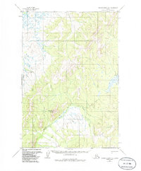
1952 · Russian Mission D-1
USGS Topo · 1:63,360