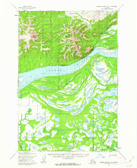
1952 Map of Russian Mission D-6
USGS Topo · Published 1962About this map
The Yukon River carves a massive divide through this Alaskan landscape, separating the high peaks of the Ilivit Mountains from the complex aquatic maze to the south. Along the northern bank, the heights of Mount Ewaklalik and Dogfish Mountain overlook small seasonal or subsistence outposts like Dogfish Village and Tuckers Fish Camp. These locations, along with the Winter Trail, reflect the vital connection between indigenous settlement patterns and the river's resources during the mid-century period.
Find a feature on this map
13 named features on this map. Tap any name to fly to it.
Don’t see what you’re looking for? This feature index may not catch every label — zoom into the map to look around manually.
Map Details
Editions of this 1952 Russian Mission D-6 Map
2 editions found
Other maps of this area

1947 · Russian Mission
USGS Topo · 1:250,000

1950 · Russian Mission
USGS Topo · 1:250,000

1951 · Holy Cross
USGS Topo · 1:250,000

1951 · Holy Cross A-5
USGS Topo · 1:63,360

1952 · Holy Cross A-4
USGS Topo · 1:63,360

1952 · Holy Cross
USGS Topo · 1:250,000
1952 · Russian Mission C-7
USGS Topo · 1:63,360
1952 · Russian Mission D-6
USGS Topo · 1:63,360

1952 · Russian Mission C-5
USGS Topo · 1:63,360
1952 · Russian Mission D-5
USGS Topo · 1:63,360