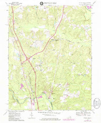
1969 Map of Ruther Glen
USGS Topo · Published 1985About this map
The Richmond Fredericksburg and Potomac rail corridor anchors this area of Caroline County, passing through the village of Ruther Glen and several rural crossroads. A notable remnant of much earlier history, a Civil War Fort, remains marked near the North Anna River at the southern edge of the sheet. The landscape is defined by its transition between early road networks and rail infrastructure, with several settlements like McDuff, Moncure Corner, and Bagdad serving as local landmarks.
Find a feature on this map
51 named features on this map. Tap any name to fly to it.
Don’t see what you’re looking for? This feature index may not catch every label — zoom into the map to look around manually.
Map Details
Editions of this 1969 Ruther Glen Map
4 editions found
Other maps of this area

1887 · Spottsylvania
USGS Topo · 1:125,000

1889 · Fredericksburg
USGS Topo · 1:125,000

1890 · Goochland
USGS Topo · 1:125,000

1892 · Fredericksburg
USGS Topo · 1:125,000

1892 · Spottsylvania
USGS Topo · 1:125,000

1892 · Goochland
USGS Topo · 1:125,000

1894 · Fredericksburg
USGS Topo · 1:125,000

1918 · Doswell
USGS Topo · 1:62,500

1942 · Bowling Green
USGS Topo · 1:31,680

1942 · Woodford
USGS Topo · 1:31,680