
2013 Map of Ruthton
USGS Topo · Published 2013About this map
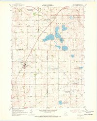
Ruthton and Florence serve as the primary anchors of this agricultural region on the edge of the Coteau des Prairies. This highland area, marked by subtle glacial topography, directs the headwaters of the Redwood River as it begins its journey across southwest Minnesota. The map shows a landscape heavily modified for modern drainage, featuring numerous engineering projects such as Judicial Ditch Number Twelve and County Ditch Number Sixteen. For those researching local roots, the area is punctuated by several burial grounds including Ruthton Cem, Opdal Cem, and Peace Cem. The presence of the Ivadelle Lakebed suggests the evolving nature of the local hydrology, while East Twin Lake and West Twin Lake remain prominent features in the undulating terrain north of the Pipestone and Murray county lines.
Find a feature on this map
47 named features on this map. Tap any name to fly to it.
Don’t see what you’re looking for? This feature index may not catch every label — zoom into the map to look around manually.
Map Details
Editions of this 2013 Ruthton Map
This is the sole edition of this map. No revisions or reprints were ever made.
Other maps of this area

1953 · Watertown
USGS Topo · 1:250,000

1953 · New Ulm
USGS Topo · 1:250,000

1957 · New Ulm
USGS Topo · 1:250,000

1958 · New Ulm
USGS Topo · 1:250,000

1958 · Watertown
USGS Topo · 1:250,000

1963 · Dead Coon Lake
USGS Topo · 1:24,000

1963 · Russell
USGS Topo · 1:24,000

1963 · Tyler
USGS Topo · 1:24,000

1967 · New Ulm
USGS Topo · 1:250,000
1967 · Ruthton
USGS Topo · 1:24,000