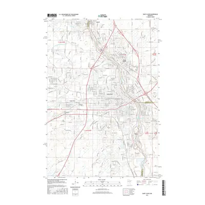
2016 Map of Saint Cloud
USGS Topo · Published 2016About this map
The Mississippi River defines the heart of this region, separating Stearns and Benton counties as it flows through a cluster of growing central Minnesota communities. The urban footprint of Saint Cloud is visible alongside its neighbors Sauk Rapids, Sartell, and Waite Park. This period of development shows a landscape where industrial transit and education are central, anchored by the Burlington Northern Santa Fe RR and the riverside campus of Saint Cloud State Univ.
Find a feature on this map
224 named features on this map. Tap any name to fly to it.
Don’t see what you’re looking for? This feature index may not catch every label — zoom into the map to look around manually.
Map Details
Editions of this 2016 Saint Cloud Map
This is the sole edition of this map. No revisions or reprints were ever made.
Other maps of this area

1950 · St. Cloud
USGS Topo · 1:62,500

1951 · Annandale
USGS Topo · 1:62,500

1953 · Saint Cloud
USGS Topo · 1:250,000

1957 · Saint Cloud
USGS Topo · 1:250,000

1958 · Saint Cloud
USGS Topo · 1:250,000

1965 · St Stephen
USGS Topo · 1:24,000

1965 · St Joseph
USGS Topo · 1:24,000

1967 · Rockville
USGS Topo · 1:24,000
1974 · Cable
USGS Topo · 1:24,000
1974 · St Augusta
USGS Topo · 1:24,000