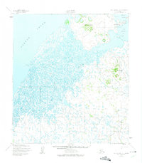
1952 Map of Saint Michael B-1
USGS Topo · Published 1975About this map
Saint Michael stands as a central hub on Saint Michael Island in the early 1950s, overlooking the waters of Saint Michael Bay and Norton Sound. This era of the settlement is defined by established infrastructure including the U. S. School Reserve, a Radio Tower, and a Landing Strip situated near the coastline. The landscape further inland is a complex network of waterways like the Saint Michael Canal and Kogok River, which navigate a terrain marked by volcanic features such as Crater Mountain and Saint Michael Mountain. Cultural and land-use landmarks such as the Russian Gardens and a Reindeer Reserve provide insight into the local subsistence and historical influence of the region. A seasonal Winter Trail connects the island to the mainland, bypassing the remote settlement at Barrabora along the coastal marshes.
Find a feature on this map
24 named features on this map. Tap any name to fly to it.
Don’t see what you’re looking for? This feature index may not catch every label — zoom into the map to look around manually.
Map Details
Editions of this 1952 Saint Michael B-1 Map
2 editions found
Other maps of this area

1951 · Unalakleet
USGS Topo · 1:250,000

1951 · St Michael
USGS Topo · 1:250,000
1952 · Saint Michael B-2
USGS Topo · 1:63,360
1952 · Saint Michael C-1
USGS Topo · 1:63,360
1952 · Saint Michael C-2
USGS Topo · 1:63,360

1952 · Saint Michael B-1
USGS Topo · 1:63,360

1952 · Saint Michael A-1
USGS Topo · 1:63,360

1952 · Saint Michael A-2
USGS Topo · 1:63,360

1952 · Unalakleet B-6
USGS Topo · 1:63,360

1952 · Unalakleet A-6
USGS Topo · 1:63,360