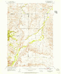
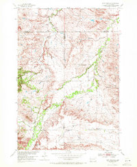
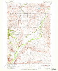
1954 Map of Saint Onge SE
USGS Topo · Published 1955About this map
Whitewood Creek carves a winding path through this western South Dakota landscape, where the intersections of Butte, Lawrence, and Meade counties meet. Surveyed in the mid-1950s as part of the Department of the Interior program for the Missouri River Basin, the map reveals a rural expanse defined by its network of country schools. Educational landmarks like Big Bottom Sch and Oakdale Sch serve as primary anchors for the surrounding ranching and farming communities. The terrain transitions from the alluvial bottomlands of Crow Creek to the distinct elevated plateau of Snake Bench in the south.
Find a feature on this map
15 named features on this map. Tap any name to fly to it.
Don’t see what you’re looking for? This feature index may not catch every label — zoom into the map to look around manually.
Map Details
Editions of this 1954 Saint Onge SE Map
4 editions found

Other maps of this area

1893 · Rapid
USGS Topo · 1:125,000

1894 · Deadwood
USGS Topo · 1:125,000

1898 · Rapid
USGS Topo · 1:125,000

1899 · Sturgis
USGS Topo · 1:62,500

1901 · Deadwood
USGS Topo · 1:125,000

1903 · Rapid
USGS Topo · 1:125,000

1905 · Saint Onge
USGS Topo · 1:62,500

1906 · Vale
USGS Topo · 1:62,500

1907 · Belle Fourche
USGS Topo · 1:125,000

1913 · Newell
USGS Topo · 1:125,000