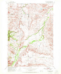
1954 Map of Saint Onge SE
USGS Topo · Published 1972About this map
Educational outposts define the mid-century landscape of this South Dakota region, where schools like Bench Sch and Oakdale Sch served the rural communities along the county lines. The terrain is characterized by a series of drainages, most notably Whitewood Creek and Cottonwood Creek, which flow through the undulating territory. Further north, Loup Sch sits near the headwaters of Ash Creek, illustrating the scattered nature of settlement during this era. A local industrial presence is noted by the Gravel Pit near Hathaway Sch, while prominent landforms such as Snake Bench provide distinct topographic markers. This 1954 field survey, published by the Geological Survey as part of the Missouri River Basin development program, captures a network of unimproved roads and light-duty paths that linked these remote schools and agricultural homesteads.
Find a feature on this map
14 named features on this map. Tap any name to fly to it.
Don’t see what you’re looking for? This feature index may not catch every label — zoom into the map to look around manually.
Map Details
Editions of this 1954 Saint Onge SE Map
4 editions found
Other maps of this area

1893 · Rapid
USGS Topo · 1:125,000

1894 · Deadwood
USGS Topo · 1:125,000

1898 · Rapid
USGS Topo · 1:125,000

1899 · Sturgis
USGS Topo · 1:62,500

1901 · Deadwood
USGS Topo · 1:125,000

1903 · Rapid
USGS Topo · 1:125,000

1905 · Saint Onge
USGS Topo · 1:62,500

1906 · Vale
USGS Topo · 1:62,500

1907 · Belle Fourche
USGS Topo · 1:125,000

1913 · Newell
USGS Topo · 1:125,000